July 3 – 4, 2009
Hidden Lake Peaks Ridge Lookout (Sort of)
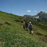
Kirsten and I headed up to Highway 20 in the North Cascades for the holiday weekend. We drove out Friday morning and got a campsite at Marble Creek Campground on the Cascade River Road. In the 5 minutes it took to pitch our tent, we were bitten by a half dozen mosquitoes. Not the greeting we were hoping for, but we hustled out of there and up the road a bit to the Hidden Lake trailhead. Our destination was the Hidden Lake Peaks Lookout; a place that has crammed several different geographic features into its name, much to the annoyance of the surrounding geography. We were the only car in the parking lot, and we started hiking at 10:30, wondering how we were the first ones on the trail. Working up a nicely maintained trail, complete with long board walks over particularly damp spots, after an hour or so, we popped out into the meadowed valley of the East Fork Sibley Creek below a prominent peak on the Hidden Lake Peaks ridge. Large cliffs lined the ridge above us, and the trail switchbacked up the valley alongside snow still filling the belly of the valley, occasionally crossing through mosquito infestations, but also charming patches of Lupine, Paintbrush, and Columbine. Below the ridge, the trail disappeared under continuous snow cover, and we began the long traverse toward the Hidden Lake Lookout with no clues to aid our navigation. We stopped traversing and aimed for a low spot on the ridge that looked accessible, but when we got there it was clear we weren’t in the right place. Even so, we were not at all disappointed with the views: Mt Baker behind us, Eldorado, Forbidden, Sahale, the Pickets, and the Ptarmigan Traverse all visible from one spot.
We descended and traversed some more, through the snow, but with the sun beating down on us harshly, we began losing some steam. We started up to another col but as we approached, we knew we still had not traversed far enough. Sure enough, when we reached the ridge, we could see the lookout at the top of the peak adjacent to us to the south, but considering Kirsten is 20 weeks pregnant, and we had already ascended a total of about 3500 feet through the heat and mosquitoes, we decided to call it good. We relaxed and had some food and took pics and pointed out different parts of the Ptarmigan Traverse, and then headed back.
We returned to the car around 5. The bugs weren’t back out yet and the parking lot was in the sun, so we got out the camp chairs and drank our cold ginger ales and soaked up the warm sunshine. After returning to the campground we made dinner on our new Coleman car camping stove, and began making notes of all the things we did wrong with our car camping setup. We essentially half packed for car camping and half packed for backpacking: we brought the Coleman, cooler, real plates and 2.5 gallon jugs of water, but we didn’t bring real utensils, meat for the pasta, or pillows for the tent! We also brought camp chairs, and cold pop, but we forgot food for the car and we only brought one pop for each of us. Not fully knowledgeable of the rules, we decided it wouldn’t be in the true spirit of camping to drive the 5 miles back to Marblemount and pick up more.
Dinner made us sufficiently full, despite its somewhat backcountryish volume, and after some organic Italian chocolate, which we readily helped ourselves to more of after discovering the surprisingly high amount of protein and fiber in it, we hung out and waited for the bugs to return. At dusk, like miserable little vampires they indeed returned, and we retreated to a defensive position inside our tent.
Thornton Lakes
Saturday morning we packed up camp after breakfast and left Cascade River Road, continuing eastward on Highway 20 to Thornton Lake Road. The road is rough, steep and narrow — we crawled up in 4-wheel drive, thankful we weren’t in the Fit, and after 5 miles reached the Thornton Lake trailhead. This trail starts out much more easily, traveling along an overgrown old logging road for about 45 minutes before the trail begins ascending and switchbacking up through old growth forest, crossing into the North Cascades National Park and toward Thornton Lakes. After another hour or so we reached the fork at the pass, and followed a rough, steep trail up toward Trappers Peak with intermittant and spectacular views of Triumph. After an hour on that trail, we reached a point at about 5700 feet, and having ascended 3,000 feet, we decided to stop. The remaining 200 feet up the path was even steeper and still about 50% snow covered, and we were sitting on a nice rock outcropping with a good view of the Pickets just one valley away on one side, Mt Triumph on the other, and across Highway 20 to the south we could see Eldorado Peak and glaciers spilling between all the other peaks mountains lined up along the highway. We relaxed for an hour and took 22,562 pictures before heading down.
We hoped to hit Good Food in Marblemount for dinner, but last 4th of July with Pete and Becky we were disappointed to find them closed for the holiday, and sure enough they were closed this year, too. So we split an over-priced milkshake from Cascadian Farms and pushed on to Taco Time in Smokey Point for dinner. These were two of the most beautiful hikes we’ve ever done, and will definitely keep them on the list for repeat trips in the future.