Tuesday, September 22, 2009

Lake Serene and Denny Creek

Lake Serene

September 12, 2009

Kirsten and I had not hiked in a while, so we weren’t sure how much to take on now that she is 30 1/2 weeks pregnant. We decided to check out the trail to Lake Serene off Highway 2, which is 7.5 miles round trip and 2,000 feet of elevation gain. Normally we would consider that quite mellow, but apparently not when you’re that far along! Kirsten was hurting pretty bad by the end. We had to stop numerous times to rest and stretch, and evaluate the source of the pain: simple muscle strain or premature labor? The former, we can work through it; the latter, not so much. It goes without saying (but I will anyway), that Kirsten was not in fact going into labor; the baby is quite fine, and after making it to Lake Serene and enjoying a long rest admiring the lake and happily watching dogs frolic in the water, we descended the trail back to the car.

Denny Creek

September 20, 2009

After the lesson we learned last weekend, we lowered our sights a bit for our hike this weekend. Kirsten is now 31 1/2 weeks! We headed to Denny Creek off I-90, which has numerous landmarks which make good turnaround points, and we aimed for some waterfalls about 2 miles in and 900 feet up. This was a much more reasonable goal. Despite the easiness of the hike, it was not wanting for interesting sites. First, the trail crosses beneath one of the massive spans of I-90 just west of Snoqualmie Pass; then reaches the natural water slides where the trail crosses Denny Creek. After climbing up the west bank above the creek, it pops out in some slide paths below the imposing cliffs of Low Mountain; then a spur trail descends back to the creek on top of some waterfalls where giant rock slabs form an impressive prompontory before heading into a narrow gorge upstream. We turned around here after taking some leisurely rests at some of the various landmarks. A fine hike, and deservedly popular. It’ll make the list for hikes to do next summer with the little one!


Saturday, July 11, 2009

Rampart Ridge

Snoqualmie Pass, WA

July 11, 2009

Rampart Ridge

Saturday, Marcus, Anastasia and Hopi joined Kirsten and I for a day hike. Marcus has been scouting out a ski line off Peak 5606 on Rampart Ridge at Snoqualmie Pass for quite some time, so he was pleasantly surprised when we proposed a hike up to one of the lakes up there. Marcus & Kirsten sleuthed out a route that started high up on the Rocky Run road, which would get us closer to the ridge and give us more options for exploring once up there. The unmaintained spur road that leads to the unmarked trailhead for the unofficial trail is in rough shape, but Plum crawled along smoothly and handled the huge rain runnels and washouts well, only suffering minor scratching from the gauntlet of brush.

From Rampart Ridge

The trail was really steep, resembled a classic climbers’ trail, obviously not put in by the Forest Service, but in very good shape, and we reached Lake Lillian after an hour or so. Hopi did a great job negotiating small stream crossings and working out moves over big rock steps. The lake was still half frozen, and snow patches lingered along the north facing slopes above the lake. After a short break, we continued beyond the lake, up the steepest part of the trail yet, and after another hour reached the top of Rampart Ridge with crystal clear views of Rainier to the south, Mt Stuart to the east, and the central Cascades to the north. We traversed the ridge north to a high point above Rampart Lakes and had lunch. Rampart Ridge is beautiful and deserving of its name. Surrounded by Glacier Lillies and nice views of Thompson, Lemah, Chikamin, Rachel Lake and Rampart Lakes, we relaxed in peace for quite a while, before heading down.

From Rampart Ridge

Friday, July 3, 2009

Highway 20 Hikes

July 3 – 4, 2009

Highway 20 Hiking

Hidden Lake Peaks Ridge Lookout (Sort of)

Kirsten and I headed up to Highway 20 in the North Cascades for the holiday weekend. We drove out Friday morning and got a campsite at Marble Creek Campground on the Cascade River Road. In the 5 minutes it took to pitch our tent, we were bitten by a half dozen mosquitoes. Not the greeting we were hoping for, but we hustled out of there and up the road a bit to the Hidden Lake trailhead. Our destination was the Hidden Lake Peaks Lookout; a place that has crammed several different geographic features into its name, much to the annoyance of the surrounding geography. We were the only car in the parking lot, and we started hiking at 10:30, wondering how we were the first ones on the trail. Working up a nicely maintained trail, complete with long board walks over particularly damp spots, after an hour or so, we popped out into the meadowed valley of the East Fork Sibley Creek below a prominent peak on the Hidden Lake Peaks ridge. Large cliffs lined the ridge above us, and the trail switchbacked up the valley alongside snow still filling the belly of the valley, occasionally crossing through mosquito infestations, but also charming patches of Lupine, Paintbrush, and Columbine. Below the ridge, the trail disappeared under continuous snow cover, and we began the long traverse toward the Hidden Lake Lookout with no clues to aid our navigation. We stopped traversing and aimed for a low spot on the ridge that looked accessible, but when we got there it was clear we weren’t in the right place. Even so, we were not at all disappointed with the views: Mt Baker behind us, Eldorado, Forbidden, Sahale, the Pickets, and the Ptarmigan Traverse all visible from one spot.

From Highway 20 Hiking

We descended and traversed some more, through the snow, but with the sun beating down on us harshly, we began losing some steam. We started up to another col but as we approached, we knew we still had not traversed far enough. Sure enough, when we reached the ridge, we could see the lookout at the top of the peak adjacent to us to the south, but considering Kirsten is 20 weeks pregnant, and we had already ascended a total of about 3500 feet through the heat and mosquitoes, we decided to call it good. We relaxed and had some food and took pics and pointed out different parts of the Ptarmigan Traverse, and then headed back.

We returned to the car around 5. The bugs weren’t back out yet and the parking lot was in the sun, so we got out the camp chairs and drank our cold ginger ales and soaked up the warm sunshine. After returning to the campground we made dinner on our new Coleman car camping stove, and began making notes of all the things we did wrong with our car camping setup. We essentially half packed for car camping and half packed for backpacking: we brought the Coleman, cooler, real plates and 2.5 gallon jugs of water, but we didn’t bring real utensils, meat for the pasta, or pillows for the tent! We also brought camp chairs, and cold pop, but we forgot food for the car and we only brought one pop for each of us. Not fully knowledgeable of the rules, we decided it wouldn’t be in the true spirit of camping to drive the 5 miles back to Marblemount and pick up more.

Dinner made us sufficiently full, despite its somewhat backcountryish volume, and after some organic Italian chocolate, which we readily helped ourselves to more of after discovering the surprisingly high amount of protein and fiber in it, we hung out and waited for the bugs to return. At dusk, like miserable little vampires they indeed returned, and we retreated to a defensive position inside our tent.

Thornton Lakes

Saturday morning we packed up camp after breakfast and left Cascade River Road, continuing eastward on Highway 20 to Thornton Lake Road. The road is rough, steep and narrow — we crawled up in 4-wheel drive, thankful we weren’t in the Fit, and after 5 miles reached the Thornton Lake trailhead. This trail starts out much more easily, traveling along an overgrown old logging road for about 45 minutes before the trail begins ascending and switchbacking up through old growth forest, crossing into the North Cascades National Park and toward Thornton Lakes. After another hour or so we reached the fork at the pass, and followed a rough, steep trail up toward Trappers Peak with intermittant and spectacular views of Triumph. After an hour on that trail, we reached a point at about 5700 feet, and having ascended 3,000 feet, we decided to stop. The remaining 200 feet up the path was even steeper and still about 50% snow covered, and we were sitting on a nice rock outcropping with a good view of the Pickets just one valley away on one side, Mt Triumph on the other, and across Highway 20 to the south we could see Eldorado Peak and glaciers spilling between all the other peaks mountains lined up along the highway. We relaxed for an hour and took 22,562 pictures before heading down.

From Highway 20 Hiking

We hoped to hit Good Food in Marblemount for dinner, but last 4th of July with Pete and Becky we were disappointed to find them closed for the holiday, and sure enough they were closed this year, too. So we split an over-priced milkshake from Cascadian Farms and pushed on to Taco Time in Smokey Point for dinner. These were two of the most beautiful hikes we’ve ever done, and will definitely keep them on the list for repeat trips in the future.

Monday, June 1, 2009

Sunday, May 24, 2009

The Brothers

The Brothers

May 23 – 24, 2009

By: Aaron Riensche

[Editorial note: The Brothers is the most prominent Olympic Mountain peak visible from Seattle, easily distinguished by the twin summits that inspired its name. It has been a tantalizing objective for quite some time, but we had never carved out an opportunity to attempt it. When Aaron and Johanna asked if we wanted to climb it over Memorial Day weekend we thought it sounded like a fun trip, and perfect considering Kirsten would just be beginning her second trimester of pregnancy!]

It was the rarest of events: a sunny Memorial Day weekend in the Pacific Northwest. The fair weather sufficed to overshadow the setbacks as we prepared for our weekend junket to The Brothers. Kirsten had just entered her second trimester of pregnancy and had been talking a few weeks prior about skipping the summit attempt. Johanna went home from work early the day before our departure with stomach pain. And I had sprained my ankle in a softball game a week and a half earlier.

Nonetheless, with clear skies and sun in the forecast all weekend, there were no second thoughts as we rolled down the freeway toward the Olympics. If Nate ended up heading to the summit all by himself, the rest of us would at least have a pleasant day by the river while we waited for him.

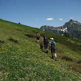
At the Lena Lake trailhead, we donned our boots and packs in a balmy sun and ventured into the forest, where we followed the many switchbacks up the hillside at a barely perceptible incline. After three miles, we emerged onto a stone platform, and Lena Lake opened up before us, a gleaming blue expanse in the shade of towering evergreens.

We stopped here for a quick lunch and then continued around to the other side of the lake where we picked up the trail to base camp. The Valley of the Silent Men did its name justice, maintaining an eerie silence through most of our hike. No chirping crickets, no singing birds, just the steady crunch of boots on earth as we made our way through the shade of moss covered branches.

The trail was a little tougher here, still only a gradual incline, but not quite as well maintained as the Lena Lake trail—more rocks and roots to trip on, more logs to climb over, and more branches to snap back into the face of the person behind. Another three miles into the forest from the lake, we reached base camp. The main camping area, at the confluence of two forks of the creek, was already full. But we found a campsite with space for two tents farther up the creek. We set up camp, and Nate did an admirable job of mimicking Dad’s mysterious art of lighting a campfire with wet wood. Then we cooked dinner and went to bed early, with plenty of sunlight still streaming through the trees and the babbling brook lulling us to sleep.

The next morning, per usual, Nate and Kirsten were far more efficient in their preparations than Johanna and I. Although we got up a half hour earlier, they had already eaten breakfast and readied their gear while we were still waiting for our breakfast water to boil.

Before we headed out, Nate offered to tape my ankle. He had been walking behind me on the hike in and was getting concerned about my hobbling and favoring my right foot. Athletic tape was in short supply, but we scrounged up enough for a light layer of ligament protection.

The sun had just come up as we left camp at 5:45 a.m. We hiked briefly through the woods and then reached an open area that a forest fire had left bare a few years back and picked our way over the charred, lifeless remains of trunks and stumps.

After a stream crossing, Kirsten was prepared to follow a trail straight up the hillside. But another group had caught up to us from behind, and its leader insisted that he had been up this mountain many times and that if we made our way through the trees to our left we would come upon the proper trail. Nate and Kirsten would both later rue breaking the cardinal rule of never assuming other people know where they’re going.

The half hour or so of bushwhacking that this advice led to put us behind schedule, and put more than a few scrapes and scratches on our arms and legs. There were many laments about how much it sucks to be lost in the woods and jokes about whether it was too soon to start rationing food. At some point, we gave up on traversing with the other group and just started hacking our way straight up hill.

Finally, we emerged from the brush, just above the tree line, and The Brothers’ south peak towered above us. We allowed ourselves a brief sigh of relief and then continued climbing.

We had ascended a few hundred feet, when I looked up and saw somebody coming down the glissade chute. Since we were close to the chute, I casually called out a warning that there were people glissading down. But even as I said these words, I wondered why this guy was flailing his arms and legs.

We watched in horror as he hurtled down the mountainside at perilous speed, frantically grasping at the icy sides of the tube and trying in vain to kick his feet into the frozen surface. We were close enough to see the look of terror on his face as he plummeted past us and fell a few hundred more feet to the snowdrift at the bottom of the chute next to the boulder where we had taken our last rest. He regained control enough to roll to one side and grab onto the boulder, and his body swung down below the boulder and out of our view.

Moments later, he stood and raised his hands and called out that he was okay. Looking up at the streaks of blood on the sides of the chute, where the ice had ripped open his bare arms, we had some doubts, but he insisted that, other than his bloody arms, he was all right. The team above us called out that they were going to send his ice ax down after him. Kirsten yelled back up to not do that under any circumstances. We decided it was time to put on our helmets.

We waited a while longer, unsure whether we should head back down and help the guy. But when the team that had led us bushwhacking into the forest earlier in the day emerged from the woods and happened upon the injured climber, we continued up.

With the living example of the consequences of carelessness fresh in our minds, Johanna and I took to heart Nate and Kirsten’s reminder to drive our toes into each kick-step and then drive our axes into the snow before moving our feet up. For a while, we continued following the previous groups’ steps diagonally up the mountainside. This tempered the trajectory a little, but it also had the negative side effect of forcing us to cross the icy glissade chute every several meters. Again, after watching someone plunge down the chute at breakneck speed, we were getting nervous about making the delicate step across it so often. Eventually we decided to stop tempting fate and just kick our own steps straight up the face. And by “we,” I mean “Nate and Kirsten,” who took on the task of forming starter steps for the rest of the team to follow.

The slope was nearly vertical for the last few hundred feet. We continued plodding upward, digging our feet into the steps and then stabbing the ice ax into the snow, resting for a second, then moving the feet up to the next steps, then moving the ax.

The snowy face was capped by a stone outcropping, requiring a short traverse to the right, where we could haul ourselves onto the shelf. The traverse was a move that none of us would have given a second thought about if we were wearing rock climbing shoes and were tied into a rope. But with heavy boots on our feet, and an ice ax in one hand, and a roughly 1,500-foot drop below, Johanna and I found it a little nerve-wracking.

Once over the shelf, our last challenge was to walk up a path littered with loose rock as gingerly as possible to avoid kicking any of it down onto the climbers beneath us as we took the final steps to the summit. Given the holiday and the gorgeous weather, it was not surprising to find the summit a bit crowded. But we managed to find a couple free rocks to sit on and eat a sandwich as we rested our legs and enjoyed the spectacular 360-degree scenery.

Rainier rose up majestically in the haze to the southeast, Baker to the northeast. To the west, the rolling green foothills gave way to the snow-capped peaks of the Olympics. And to the east, the Hood Canal flowed into the Sound.

[Editorial note: congratulations to Aaron and Johanna on their first technical summit, but also it was Kirsten's and my baby's first summit! Hopefully this will burn a lasting love of the mountains in the baby.]

On the way down, traffic jammed at the traverse from the shelf across the rocky outcropping and back onto the snowfield. Then, for about a hundred feet, we moved delicately downward, driving the ice ax handle deep into the snow, then hanging onto the ax head for dear life as we moved our feet down a few inches to the next steps, kicking a firm foothold, and then finding a new hole for the ax. (This might be a good time to say thank you to Marcus and Anastasia for lending us their axes. Thanks, guys.)

The painstaking process was exacerbated not immeasurably by the occasional falling rock kicked down by the climbers coming and going from the summit. By this time, there was a line of people making their way down the gully, and every few minutes someone would yell, “Rock!”—sometimes followed by, “Oh shit, really big rock!”—and we would flatten our bodies and bury our faces in the snow and hope whatever was coming down would pass us by.

When we passed the steepest, most frozen part, thinking we had been pushing our luck in the shooting gallery a little too long, we turned around and started plunge-stepping down. Then, when the slope eased up some more, Johanna and I started glissading. At the bottom of the snow field, we found the trail down the gully, which offered an impressive view of the south peak and a small waterfall, and considerably less bushwhacking than our route up.

Back at camp, we barely had time to take off our boots for a few minutes before we had to break camp and start down the trail. It was 5:30 p.m. when we left, and we still had a six-mile hike ahead of us. Ignoring our aching feet (not to mention shoulders, legs, backs, etc.), we limped down the hillside and barely made it out of the woods by nightfall. Then, in the last of a long list of things to thank Nate and Kirsten for over the weekend, Nate drove while Kirsten kept him awake, and Johanna and I slept like babies in the backseat all the way back to Seattle.

Monday, February 16, 2009

Rogers Pass, BC

We drove out to Rogers Pass on Friday, February 13 (Aaron’s birthday), leaving Seattle at 1 in the afternoon with Pete and Becky in Plum with us and Murray and Andy in Andy’s car. On Saturday the 14th (Valentine’s Day), we did a shake down trip up to the Lilly Glacier. The tour was beautiful, but I would rate the snow as just okay. Despite the advantage of being north facing, the slopes were pretty heavily windswept. Marcus & Anastasia showed up Saturday night, coming straight from Seatac after Anastasia returned from the Philippines. On Sunday, Kirsten, Andy, Murray, Pete, Becky and I did a tour towards Balu Pass to a north-facing bowl on Cheops, while Marcus & Anastasia did a jetlag recovery tour up to Bruins Pass. We found pretty good, old powder in the bowl sheltered from wind effect. Monday (Presidents Day in the U.S., Family Day in Canada), despite heavy legs from the last two days, Pete, Becky, Kirsten and I did the Youngs Peak Tour, starting up toward Lookout Peak, across the Illicelliwaet Glacier, up the final slopes of Youngs Peak, and then skied down the Asulkan Valley. The tour was exhausting, but incredibly beautiful, climbing below Mt Sir Donald, along the edge of the massive Illicelliwaet NĂ©ve, up the convoluted north ridge of Youngs Peak, and then to top it off, we managed to find open slopes of well-preserved old powder on the descent. We regrouped down in Revelstoke for dinner, then skied Tuesday morning at the Revelstoke ski resort before driving home.

Sunday, January 4, 2009